Korčula
About this place
Korčula island cannot be reduced to the silhouette of its namesake town. The eastern side lends itself to urban walks and visits towards Lumbarda, while the western area around Vela Luka offers a different relationship between settlement, bay and archaeological heritage. Vela Spila above Vela Luka demonstrates that the island's story begins long before palaces and walls. Its visitor arrangements need checking, however, because the official language versions do not provide entirely consistent notices. For travellers, the key distinction is between choosing an arrival port and choosing accommodation: landing at one end does not make the opposite end immediately accessible. Korčula suits a stay that alternates the historic town with coastline, short walks and other settlements. Rather than compressing the whole island into one day, select an eastern or western circuit and explore the other separately. That geographic breadth is precisely what distinguishes an island holiday from a day trip to the old town. For families and visitors without a car, actual transport connections from the accommodation matter more than the number of attractions marked on a map.
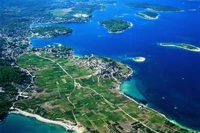
Korčula's walled town reveals little of the long island's agricultural interior: fields spread around Blato and Lumbarda, with the vineyards of Čara and Smokvica and villages below the ridge between them. Klupca, the highest point, reaches 569 metres, while evergreen oak woodland recalls the ancient name Korkyra Melaina, Black Korčula. Žrnovo consists of distinct hamlets with their own churches and traditions, including the Moštra sword dance in Postrana. Račišće faces the Pelješac Channel; on the opposite coast, Pupnatska Luka sits below steep slopes beside a pebble beach. The island's character belongs as much to Lumbarda's winegrowers and western farming communities as to the stonework of Korčula town.
Top places

Žrnovo
Village · Korčula

Stays
No stays listed here yet
Things to see
The Barilo Ethnographic House in Blato recreates an island household through its hearth, kitchen, bedroom and tinel, the traditional sitting room. Inside the ancestral Marinović Barilo home, Velimir and Dita Škrablin assembled costumes, needlework and objects used in farming, fishing and domestic life over several decades. Local aromatic plants in Barilo's garden add a living element to the collection of household furnishings. In Vela Luka, the Culture Centre's museum collection holds material excavated at Vela Spila, including pottery and other evidence of prehistoric life. Together, Barilo and the Vela Luka museum approach Korčula's past through things people made and handled, from textiles to ceramics.

Beaches
Lumbarda's Pržina and Bilin žal are both sandy, but face different sides of the island: Pržina looks south, while Bilin žal faces Pelješac and the islets off eastern Korčula. Vineyards lie behind Pržina, whereas an old stone building helps define the shore at Bilin žal. Tatinja brings a sandy beach closer to Lumbarda village, with views towards Vrnik and Gubavac. Pupnatska Luka offers pebbles instead, in a southern bay below Pupnat. Choosing between Pupnatska Luka and Lumbarda therefore involves a genuine difference in beach surface: the southern cove is not an extension of the sandy landscape around Pržina.
Things to do
For your first day, choose the part of Korčula genuinely accessible from your port or accommodation. In the east, that might mean the old town, one cultural visit and an outing towards Lumbarda. In the west, Vela Luka's waterfront and interpretation of prehistory form a more coherent combination. Vela Spila is not simply a natural cave for a cooling stop; arrange the approach and visit around a current opening confirmation. With three days, devote the first to your base, the second to another island area and the third to relaxation or a return to the place that most interested you. This often works better than crossing the entire island every day. Outings to the smaller islets near Vela Luka are sea excursions requiring a return plan and suitable weather. Moreška and other cultural events belong to specific communities and organisers, not an identical programme in every harbour. In smaller settlements, settle food and transport arrangements for arrival day beforehand. Leave a generous margin before the return boat rather than adding a final distant attraction.
Activities
The approach to Kočje starts from Brdo, a hamlet of Žrnovo, and leads towards rocky passages beneath evergreen oaks. Kočje is not a summit walk: its distinctive features are the protected woodland's boulders, crevices and mature trees. Around Lumbarda, a walk between Pržina and Bilin žal passes through the sandy vineyard landscape associated with the Grk grape. Žrnovo also offers a local skill that can be eaten: makaruni pasta is shaped around a slender wooden stick, a process demonstrated beyond domestic kitchens during Makarunada. Watching the rolling technique in Žrnovo adds something that ordering a plate of makaruni with sauce cannot show on its own.
Day trips
Proizd lies outside the entrance to Vela Luka bay, where pale rock and rocky bathing spots offer a contrast to Lumbarda's sandy beaches. Vela Luka is the departure base for Proizd, allowing an island outing to be paired with the museum collection of finds from Vela Spila. Ošjak is another islet in Vela Luka bay, so distinguish an Ošjak trip from a crossing to Proizd when choosing a boat excursion. At Korčula's eastern end, Bilin žal looks towards Pelješac, which is also reached by the Dominče–Orebić ferry. Travellers taking a car to Orebić board at Dominče rather than Korčula town's waterfront passenger quays.
Food and drink
Žrnovski makaruni is one of Korčula's distinctive dishes: hand-shaped pasta served with a meat sauce, with its preparation showcased at Žrnovo's Makarunada. For wine, distinguish Lumbarda's Grk from Pošip grown in the island's central vineyards, particularly around Čara and Smokvica. Grk is a white wine associated with Lumbarda's sandy soils; Bire is one local producer working with the variety. Autumn in Vela Luka brings lumblija, a sweet bread flavoured with spices and varenik, reduced grape must. Lumblija also belongs to the local custom of giving gifts before All Saints' Day, connecting the bread with Vela Luka's kolinde tradition rather than treating it simply as a dessert.
Towns
Korčula
Town · Korčula
All other placesShow all 2Hide list
Practical information
Practical information
Waterfront names help prevent arrival at the wrong boarding point in eastern Korčula: the town's eastern quay is Obala Vinka Paletina, the western quay is Obala dr. Franje Tuđmana, and car ferries use Dominče. Match the Korčula port location to the actual service rather than relying solely on the island name printed on a map. For a cultural visit in the west, distinguish Vela Luka's Culture Centre, which holds finds from Vela Spila, from the cave above the settlement. Barilo in Blato is at number 10 on 90. ulica: Blato's numbered streets use a different address system from Korčula town's named waterfronts.
Parking
In June 2026, Korčula introduced a smart parking system displaying occupancy at four locations: the Spot shopping centre roof, the car park in front of Spot, the municipal garage and the eastern waterfront. Two approach-road displays direct drivers towards these locations rather than requiring a search beside the historic centre. Spot's roof and the municipal garage are separate entries in the system, although both names commonly appear when planning arrival in Korčula town. Hober operates the public parking facilities and publishes the relevant conditions for each location and user category. Lumbarda's beach parking is separate: Pržina and Bilin žal are not among those four occupancy displays.
Getting there and around
Jadrolinija route 634 links Orebić on Pelješac with Dominče on Korčula, while route 604 carries vehicles from Split to Vela Luka and continues to Ubli on Lastovo on selected departures. The operator's 2026 ticket rules distinguish these journeys: an Orebić–Dominče ticket is valid for departures on the chosen day, whereas Split–Vela Luka bookings reserve a particular sailing. Vela Luka is therefore not another quay in Korčula town but a port at the opposite end of the island. Korčula town's passenger berths occupy its eastern and western waterfronts; the vehicle connection with Orebić uses the separate terminal named Dominče.
Frequently asked questions
Does this guide cover only Korčula town?
No; it covers the island. The town has a separate record.
Is every port equally convenient for my accommodation?
No. Compare the arrival port and onward land journey before booking.
Is Vela Spila definitely open?
Official language pages contain conflicting notices; confirm directly before setting out.
Should I cross the whole island every day?
No. Grouping places in the same island area is more practical.
Are small-island excursions weather independent?
Related guides

Blato, Korčula
Blato is not a seaside centre but a historic inland settlement in western Korčula’s fertile interior, while its municipality reaches Prigradica on the north coast and Prižba, Gršćica,…
Read the guide
Help improve this page
Spot something missing or wrong? Suggest a correction, add your photo or report a problem. Editors review every suggestion before it is published.
Photo credits
- Korčula, Žrnovo — Quahadi Añtó 07:12, 19 July 2011 (UTC) · CC BY 3.0 · Wikimedia Commons
- Račišće — Quahadi Añtó 10:17, 15 December 2010 (UTC) · CC BY-SA 3.0 · Wikimedia Commons
- Blato, Korčula — Quahadi Añtó 19:10, 5 June 2012 (UTC) · CC BY-SA 3.0 · Wikimedia Commons